Tonga Volcanoes
-

Kao
-

Curacoa
-
Curacoa
-
Curacoa
-
Fonuafo'ou
-
Tofua
-
Home Reef
-
West Mata
-
Home Reef
-
Kao
-
West Mata
-
Tofua
-
Unnamed
-
West Mata
-
Lateiki
-
Fonuafo'ou
-
Tofua
-
West Mata
-

Home Reef
-
Home Reef
Tonga has 21 Holocene volcanoes. Note that as a scientific organization we provide these listings for informational purposes only, with no international legal or policy implications. Volcanoes will be included on this list if they are within the boundaries of a country, on a shared boundary or area, in a remote territory, or within a maritime Exclusive Economic Zone. Bolded volcanoes have erupted within the past 20 years. Suggestions and data updates are always welcome ().
| Volcano Name | Location | Last Eruption | Primary Volcano Type |
|---|---|---|---|
| Curacoa | Tonga Ridge | 1979 CE | Complex |
| Dugong | Northwest Lau Basin | Unknown - Evidence Uncertain | Shield |
| Fonuafo'ou | Tonga Ridge | 1936 CE | Stratovolcano |
| Fonualei | Tonga Ridge | 1957 CE | Stratovolcano |
| Home Reef | Tonga Ridge | 2023 CE | Stratovolcano |
| Hunga Tonga-Hunga Ha'apai | Tonga Ridge | 2022 CE | Caldera |
| Kao | Tonga Ridge | 1847 CE | Stratovolcano |
| Late | Tonga Ridge | 1854 CE | Stratovolcano |
| Lateiki | Tonga Ridge | 2019 CE | Stratovolcano |
| Lobster | Northwest Lau Basin | Unknown - Evidence Uncertain | Shield |
| Niuafo'ou | Tonga Ridge | 1946 CE | Shield |
| Niuatahi | Northeast Lau Basin (Tonga) | Unknown - Unrest / Holocene | Caldera |
| Tafahi | Tonga Ridge | Unknown - Evidence Uncertain | Stratovolcano |
| Tafu-Maka | Northeast Lau Basin | 2008 CE | Fissure vent |
| Tofua | Tonga Ridge | 2014 CE | Caldera |
| Unnamed | Tonga Ridge | Unknown - Unrest / Holocene | Stratovolcano |
| Unnamed | Tonga Ridge | Unknown - Evidence Credible | Stratovolcano |
| Unnamed | Tonga Ridge | 1932 CE | Stratovolcano |
| Unnamed | Tonga Ridge | 2017 CE | Stratovolcano |
| Unnamed | Tonga Ridge | 2019 CE | Stratovolcano |
| West Mata | Lau Rear-Arc | 2009 CE | Fissure vent(s) |
Chronological listing of known Holocene eruptions (confirmed or uncertain) from volcanoes in Tonga. Bolded eruptions indicate continuing activity.
| Volcano Name | Start Date | Stop Date | Certainty | VEI | Evidence |
|---|---|---|---|---|---|
| Home Reef | 2023 Oct 12 | 2023 Oct 19 | Confirmed | Observations: Reported | |
| Home Reef | 2022 Sep 10 | 2022 Oct 17 | Confirmed | 2 | Observations: Reported |
| Hunga Tonga-Hunga Ha'apai | 2021 Dec 20 | 2022 Jan 15 | Confirmed | 5 | Observations: Reported |
| Lateiki | 2019 Oct 13 | 2019 Oct 22 | Confirmed | 1 | Observations: Reported |
| Unnamed | 2019 Aug 6 | 2019 Aug 8 | Confirmed | 3 | Observations: Satellite (visual) |
| Unnamed | 2017 Jan 23 | 2017 Jan 31 | Confirmed | 0 | Observations: Reported |
| Tofua | 2015 Oct 2 | 2024 Apr 19 (continuing) | Confirmed | 0 | Observations: Reported |
| Hunga Tonga-Hunga Ha'apai | 2014 Dec 19 | 2015 Jan 23 ± 3 days | Confirmed | 3 | Observations: Reported |
| Hunga Tonga-Hunga Ha'apai | 2009 Mar 17 (?) | 2009 Mar 22 ± 1 days | Confirmed | 2 | Observations: Reported |
| Tafu-Maka | 2008 Nov 16 (?) ± 15 days | 2008 Nov 16 (?) ± 15 days | Confirmed | 0 | Observations: Reported |
| West Mata | 2008 Nov 16 (in or before) ± 15 days | 2009 May 16 (in or after) ± 15 days | Confirmed | 0 | Observations: Reported |
| Home Reef | 2006 Aug 7 | 2006 Aug 16 (?) | Confirmed | 2 | Observations: Reported |
| Tofua | 2004 Mar 19 | 2014 Oct 18 | Confirmed | 1 | Observations: Reported |
| Unnamed | 2001 Sep 27 | 2001 Sep 28 (?) | Confirmed | 2 | Observations: Reported |
| Unnamed | 1999 Jan 8 (in or before) | 1999 Jan 14 (?) | Confirmed | 1 | Observations: Reported |
| Lateiki | 1995 Jun 6 | 1995 Jun 23 ± 2 days | Confirmed | 2 | Observations: Reported |
| Tofua | [1993 Apr 29] | [Unknown] | Uncertain | ||
| Lateiki | 1991 Jun 24 (in or before) | Unknown | Confirmed | 0 | Observations: Reported |
| Hunga Tonga-Hunga Ha'apai | 1988 Jun 1 | 1988 Jun 3 (in or after) | Confirmed | 0 | Observations: Reported |
| Niuafo'ou | [1985 Mar 21] | [1985 Mar 22] | Uncertain | ||
| Home Reef | 1984 Mar 1 | 1984 Mar 5 | Confirmed | 3 | Observations: Reported |
| Curacoa | 1979 May 14 | Unknown | Confirmed | 1 | Observations: Reported |
| Lateiki | 1979 May 10 (in or before) | 1979 Jul 21 (in or after) | Confirmed | 2 | Observations: Reported |
| Fonualei | [1974 Feb 16] | [Unknown] | Uncertain | ||
| Curacoa | 1973 Jul 11 | 1973 Jul 16 | Confirmed | 3 | Observations: Reported |
| Unnamed | [1970 Jan 3] | [1970 Jan 3] | Uncertain | ||
| Lateiki | 1967 Dec 11 (in or before) | 1968 Jan 4 ± 4 days | Confirmed | 2 | Observations: Reported |
| Tofua | 1958 Dec 31 ± 120 days | 1960 Jul 2 (?) ± 182 days | Confirmed | 2 | Observations: Reported |
| Fonualei | 1957 Jun 16 ± 15 days | Unknown | Confirmed | Observations: Reported | |
| Fonualei | 1951 Aug 21 | Unknown | Confirmed | 2 | Observations: Reported |
| Niuafo'ou | [1947 Jan] | [Unknown] | Uncertain | ||
| Niuafo'ou | 1946 Sep 9 | 1946 Sep 17 | Confirmed | 2 | Observations: Reported |
| Niuafo'ou | 1943 Sep 26 | 1943 Oct 16 ± 30 days | Confirmed | 2 | Observations: Reported |
| Fonualei | 1939 Jun | Unknown | Confirmed | 2 | Observations: Reported |
| Hunga Tonga-Hunga Ha'apai | 1937 | Unknown | Confirmed | 2 | Observations: Reported |
| Fonuafo'ou | 1936 Jun | Unknown | Confirmed | 2 | Observations: Reported |
| Niuafo'ou | 1935 Dec 7 | 1936 Feb (?) | Confirmed | 2 | Observations: Reported |
| Fonuafo'ou | 1933 Apr | Unknown | Confirmed | 2 | Observations: Reported |
| Unnamed | 1932 Dec 1 ± 30 days | Unknown | Confirmed | 0 | Observations: Reported |
| Niuafo'ou | 1929 Jul 25 | 1929 Jul 26 | Confirmed | 2 | Observations: Reported |
| Fonuafo'ou | 1927 Oct 4 | 1928 Sep (in or after) | Confirmed | 2 | Observations: Reported |
| Unnamed | 1923 Jul 1 | Unknown | Confirmed | 0 | Observations: Reported |
| Fonuafo'ou | [1921 Nov] | [Unknown] | Uncertain | ||
| Niuafo'ou | 1912 Oct 15 ± 5 days | Unknown | Confirmed | 2 | Observations: Reported |
| Hunga Tonga-Hunga Ha'apai | 1912 Apr 29 | Unknown | Confirmed | 2 | Observations: Reported |
| Unnamed | 1911 Aug | Unknown | Confirmed | 0 | Observations: Reported |
| Unnamed | 1907 Jul | Unknown | Confirmed | 0 | Observations: Reported |
| Tofua | 1906 Dec | Unknown | Confirmed | 2 | Observations: Reported |
| Fonualei | 1906 Mar | Unknown | Confirmed | Observations: Reported | |
| Tofua | 1906 Jan | 1906 Feb | Confirmed | 2 | Observations: Reported |
| Fonuafo'ou | [1894 Dec] | [Unknown] | Uncertain | ||
| Lateiki | [1894 (in or before)] | [Unknown] | Uncertain | ||
| Niuafo'ou | [1887] | [Unknown] | Uncertain | ||
| Niuafo'ou | 1886 Aug 31 | 1886 Sep 18 (?) | Confirmed | 4 | Observations: Reported |
| Lateiki | 1886 | Unknown | Confirmed | 2 | Observations: Reported |
| Fonuafo'ou | 1885 Oct 12 (?) | 1886 | Confirmed | 3 | Observations: Reported |
| Tofua | 1885 Oct (in or before) | Unknown | Confirmed | 2 | Observations: Reported |
| Lateiki | 1878 Apr (in or before) | Unknown | Confirmed | 2 | Observations: Reported |
| Fonuafo'ou | 1877 | Unknown | Confirmed | 2 | Observations: Reported |
| Niuafo'ou | 1867 Apr 12 | Unknown | Confirmed | 1 | Observations: Reported |
| Fonuafo'ou | [1865] | [Unknown] | Uncertain | ||
| Lateiki | 1858 | Unknown | Confirmed | 2 | Observations: Reported |
| Home Reef | [1857] | [Unknown] | Uncertain | ||
| Tofua | 1854 | Unknown | Confirmed | 2 | Observations: Reported |
| Late | 1854 | Unknown | Confirmed | 2 | Observations: Reported |
| Niuafo'ou | 1853 Jun 24 | 1853 Jun 24 (?) | Confirmed | 0 | Observations: Reported |
| Home Reef | 1852 | Unknown | Confirmed | 2 | Observations: Reported |
| Lateiki | [1852] | [Unknown] | Uncertain | ||
| Lateiki | 1851 | Unknown | Confirmed | 0 | Observations: Reported |
| Kao | 1847 Jul 10 (in or before) | Unknown | Confirmed | 2 | Observations: Reported |
| Tofua | 1847 Jul 10 (in or before) | Unknown | Confirmed | 1 | Observations: Reported |
| Fonualei | 1846 Jun 11 (?) | 1846 Oct 10 (in or after) | Confirmed | 4 | Observations: Reported |
| Tofua | 1845 Jul 1 ± 60 days | Unknown | Confirmed | Observations: Reported | |
| Niuafo'ou | [1814] | [Unknown] | Uncertain | ||
| Tofua | 1792 | Unknown | Confirmed | 0 | Observations: Reported |
| Fonualei | 1791 | Unknown | Confirmed | 2 | Observations: Reported |
| Late | 1790 | Unknown | Confirmed | 2 | Observations: Reported |
| Lateiki | 1781 (in or before) | Unknown | Confirmed | 2 | Observations: Reported |
| Fonuafo'ou | [1781] | [Unknown] | Uncertain | ||
| Fonualei | [1780 (in or before)] | [Unknown] | Uncertain | ||
| Tofua | 1774 Jun | Unknown | Confirmed | 2 | Observations: Reported |
| Hunga Tonga-Hunga Ha'apai | 1110 ± 70 years | Unknown | Confirmed | Isotopic: 14C (calibrated) |
Tonga has 29 Pleistocene volcanoes. Note that as a scientific organization we provide these listings for informational purposes only, with no international legal or policy implications. Volcanoes will be included on this list if they are within the boundaries of a country, on a shared boundary or area, in a remote territory, or within a maritime Exclusive Economic Zone. Suggestions and data updates are always welcome ().
| Volcano Name | Location | Primary Volcano Type |
|---|---|---|
| Ata Volcanic Complex | Tonga Ridge | Unknown |
| East Mata | Lau Rear-Arc | Compound |
| Feinga Seamount | Tonga Ridge | Complex |
| Niua Volcanic Complex | Tonga Islands | Complex |
| Niuatoputapu | Tonga Islands | Stratovolcano |
| Northern Matas | Lau Rear-Arc | Volcanic field |
| Toku | Tonga Ridge | Stratovolcano |
| Unnamed | Tonga Ridge | Stratovolcano |
| Unnamed | Tonga Ridge | Stratovolcano |
| Unnamed | Tonga Ridge | Stratovolcano |
| Unnamed | Tonga Ridge | Stratovolcano |
| Unnamed | Tonga Ridge | Stratovolcano |
| Unnamed | Tonga Ridge | Stratovolcano |
| Unnamed | Tonga Ridge | Stratovolcano |
| Unnamed | Tonga Ridge | Stratovolcano |
| Unnamed | Tonga Ridge | Stratovolcano |
| Unnamed | Tonga Ridge | Stratovolcano |
| Unnamed | Tonga Ridge | Stratovolcano |
| Unnamed | Tonga Ridge | Stratovolcano |
| Unnamed | Tonga Ridge | Stratovolcano |
| Unnamed | Tonga Ridge | Stratovolcano |
| Unnamed | Tonga Ridge | Stratovolcano |
| Unnamed | Tonga Ridge | Stratovolcano |
| Unnamed | Tonga Ridge | Stratovolcano |
| Unnamed | Tonga Ridge | Stratovolcano |
| Unnamed | Tonga Ridge | Stratovolcano |
| Unnamed | Tonga Ridge | Stratovolcano |
| Unnamed | Tonga Ridge | Stratovolcano |
| Unnamed | Tonga Ridge | Stratovolcano |
There are 20 photos available for volcanoes in Tonga.
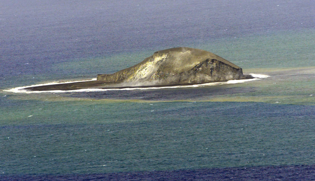
 A partially eroded pumice cone formed during an eruption that began on 7 August 2006 is seen from the N on 18 December. By the end of the year, wave erosion had destroyed the cone. Floating dacite pumice from this eruption traveled as far as Australia. Home Reef, a submarine volcano midway between Metis Shoal and Late Island in the central Tonga islands, was first reported active in the mid-19th century, when an ephemeral island formed.
Photo courtesy of Royal New Zealand Air Force and Institute of Geological & Nuclear Sciences, 2006.
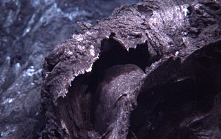
 The active crater of Fonuafo'ou (formerly known as Falcon Island) through the SE breach and a plume that is dispersed to the NW by dominant SE Trade Winds. The ephemeral island in the central part of the Tonga Islands had been named after the British vessel H.M.S. Falcon, which reported the shoal in 1865. This volcano has been the site of eruptions on at least two occasions since the 19th century. By 1949 the island had eroded beneath sea level, but the summit of the volcano remains at shallow depths.
Photo by A. Thompson (published in Taylor and Ewart, 1997).
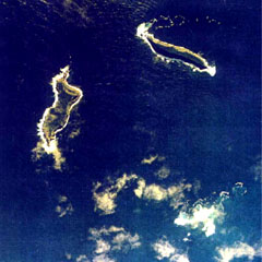 The small islands of Hunga Tonga (upper right) and Hunga Ha'apai (left) are the peaks a large seamount located about 30 km SSE of Falcon Island. The two islands are about 2 km long. They have inward-facing cliffs that represent the W and N remnants of the rim of a largely-submarine caldera lying E and S of the islands. A shoal is visible 3.2 km SE of Hunga Ha'apai and 3 km south of Hunga Tonga and marks the most prominent historically active vent.
Aerial photo by Tonga Ministry of Lands, Survey, and Natural Resources, 1991 (published in Taylor and Ewart, 1997).
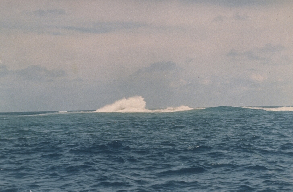
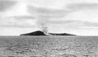
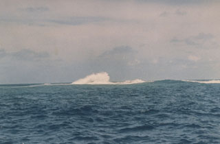 Waves break over Metis Shoal on 19 February 1968, more than a month after the end of a submarine eruption that began in December 1967 and produced an ephemeral island. Metis Shoal has produced a series of small islands during eruptions observed since the mid-19th century. An eruption in 1995 produced a lava dome that built up to 43 m above sea level.
Photo by Charles Lundquist, 1968 (Smithsonian Astrophysical Observatory).
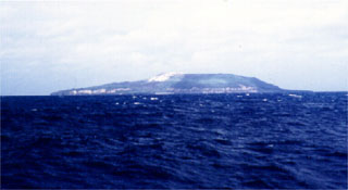
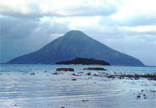 The small 1.2 x 2.8 km wide island of Tafahi is a conical stratovolcano that rises more than 500 m out of the ocean about 7 km N of Niuatoputapu. No historical eruptions have been reported, but its youthful morphology suggests recent activity.
Photo by Paul Taylor (published in Taylor and Ewart, 1997).
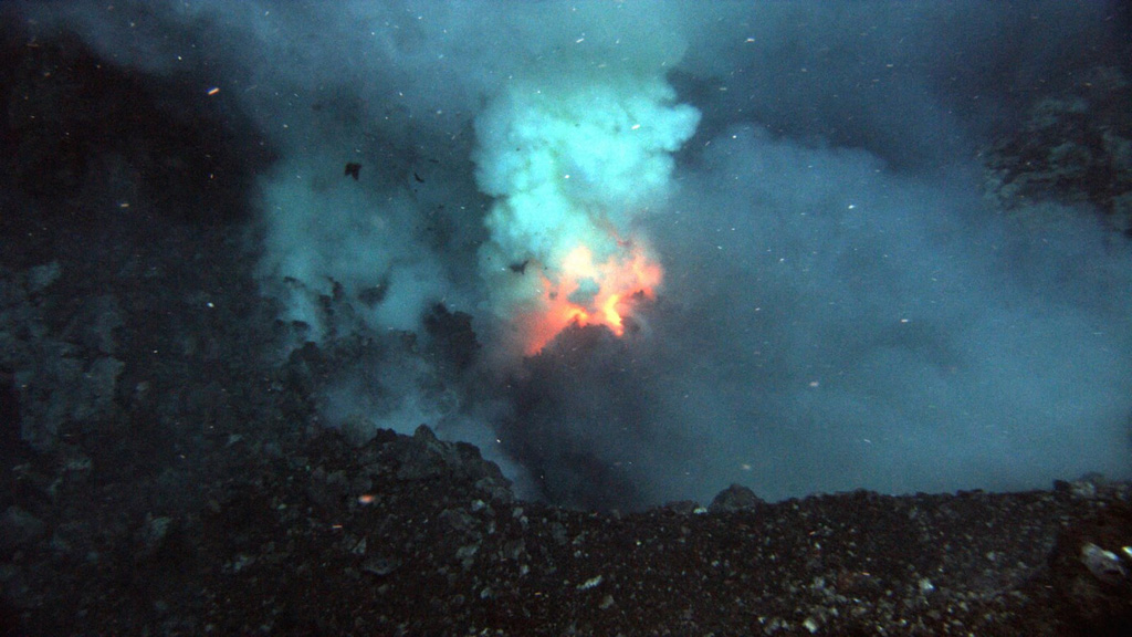
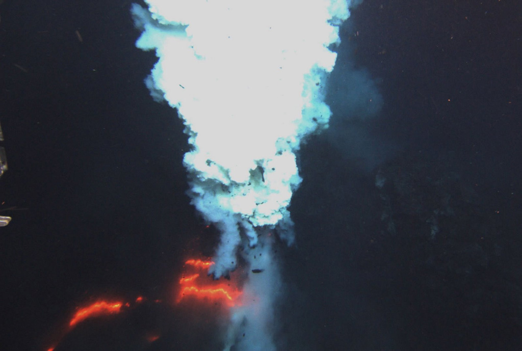
 Incandescence and a plume at the Hades vent of West Mata in May 2009, a submarine volcano with a summit more than 1,000 m below the ocean surface. The volcano is located in the northeastern Lau Basin at the northern end of the Tonga arc, about 200 km SW of Samoa. It was discovered during a November 2008 NOAA Vents Program expedition, when West Mata was observed producing submarine hydrothermal plumes consistent with recent or ongoing lava effusion. A return visit in May 2009 documented explosive and effusive activity.
Courtesy of NSF and NOAA Ocean Exploration Program, 2009.
 Floating pumice partially fills North Bay along the southern coast of Kadavu, Fiji, on 30 September 2006. This photo was taken about seven weeks after a submarine eruption began on 7 August at Home Reef, in the Tonga Islands. Wide tracks of floating pumice extended across the SW Pacific, and by March and April of 2007 had washed up along a 1,300-km-long stretch of the eastern Australian coast.
Photo by Roger Matthews, 2006 (published in GVN Bulletin).
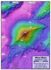 A NOAA Vents Program bathymetric map shows West Mata volcano that rises about 1,500 m from the sea floor at the N end of the Tonga arc. Submarine eruptions were detected in 2008 and 2009 from two vents. The lower flanks of East Mata volcano are visible at the middle right.
Courtesy of NSF and NOAA Ocean Exploration Program, 2009.
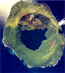
 Niuafo'ou is a low, 8-km-wide ring-shaped island that forms the summit of a largely submerged shield volcano. The 5-km-wide caldera is seen here from its eastern rim, displaying caldera lakes, the large Vai Lahi (background), and the much smaller Vai Si'i (foreground). The caldera is mostly filled by Vai Lahi with a lake bottom that extends to below sea level. Historical eruptions recorded since 1814 have often damaged villages on the island.
Photo by Paul Taylor (published in Taylor and Ewart, 1997).
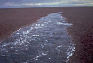 A raft of floating pumice from a July 1973 submarine eruption behind the wake of a ship. This was the first report of an eruption from the Curacoa submarine volcano in the northern Tonga Islands. The pumice raft covered an area of more than 100 km2 and was encountered by a ship 200 km to the W nearly two weeks after the start of the eruption. Another eruption was observed in the same general area in 1979.
Photo by the crew of the vessel "Port Nicholson," 1973 (courtesy of Tom Simkin, Smithsonian Institution).
 An eruption of Home Reef in the Tonga Islands in March 1984 produced an island with an estimated size of 500 x 1,500 m and a height of 30-50 m. A plume to 12 km height was reported during the 1-5 March eruption and large amounts of floating pumice were later encountered by passing ships. This photo, taken on 23 March 1984, shows water discoloration surrounding the ephemeral island.
Photo by P.J.R. Shepherd (Royal New Zealand Air Force; courtesy of John Latter, DSIR, published in SEAN Bull., 1984).
 Young curtain lava flow draped and folded over the landscape originated from the Puipui eruption of Maka volcano along the NE Lau Spreading Center, as photographed during a 2009 NOAA Vents Program expedition. A previous expedition documented submarine hydrothermal plumes from Maka volcano on 21 November 2008. The chemistry of water samples suggested that these fluids could be warmed by a recent (days or weeks?) eruption of lava onto the seafloor. A return visit in May 2009 showed fresh lava flows, but without gas emission.
Courtesy of NSF and NOAA Ocean Exploration Program, 2009.
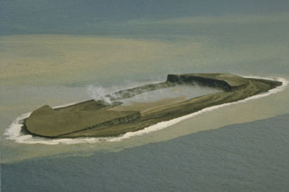
 A small plume rises from Lofia cone on the N side of the caldera lake of Tofua volcano in this 1990 aerial photograph. Recent tephra was emplaced onto the caldera rim to the NW. The steep walls of the 5-km-wide caldera are about 500 m high. Three post-caldera cones were constructed at the N end of a cold fresh-water caldera lake, whose surface lies only 30 m above sea level.
 Aerial photo by Tonga Ministry of Lands, Survey, and Natural Resources, 1990 (published in Taylor and Ewart, 1997).
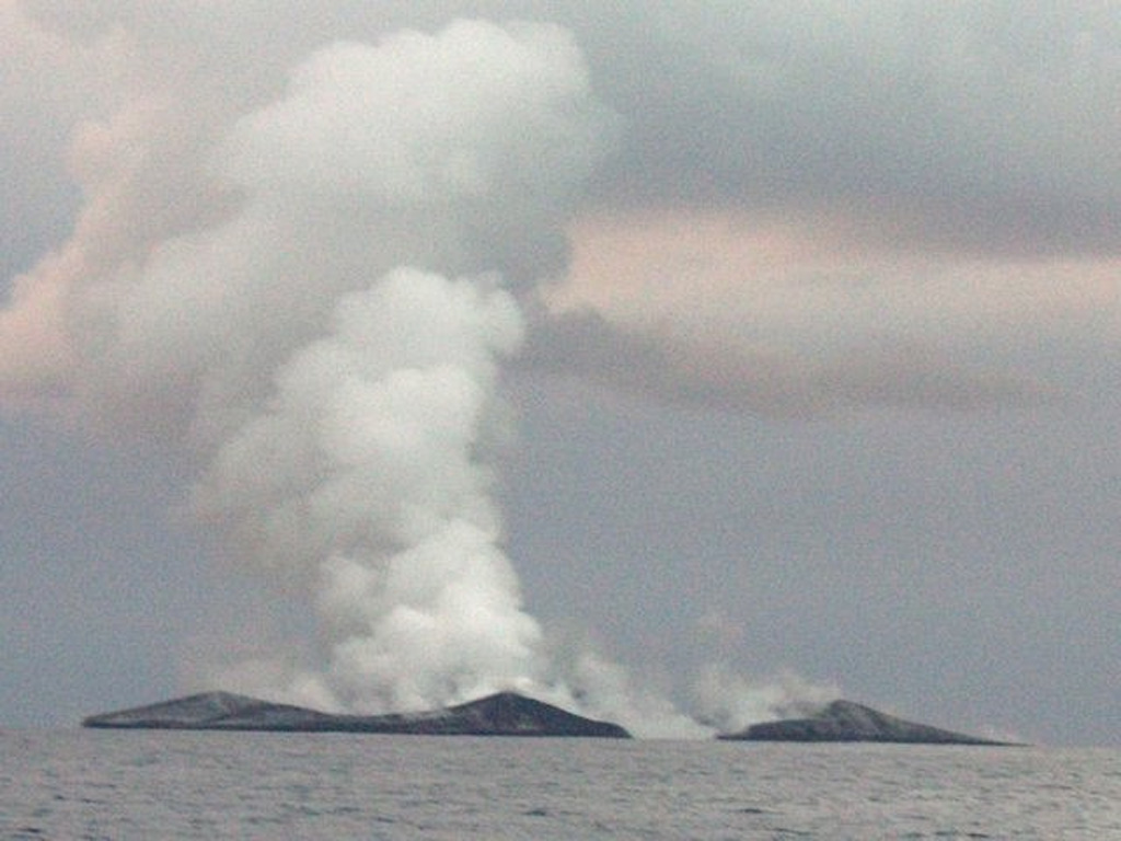
 Plumes rise above a new island being built by the eruption at Home Reef as seen from the east about 2.8 km away on 12 August 2006. The island at this time was ~1.5 km in diameter. The eruption began on 7 August and lasted until about the 16th. Widespread pumice rafts reached Fiji and as far as Australia.
Photo by Fredrik Fransson, 2006.
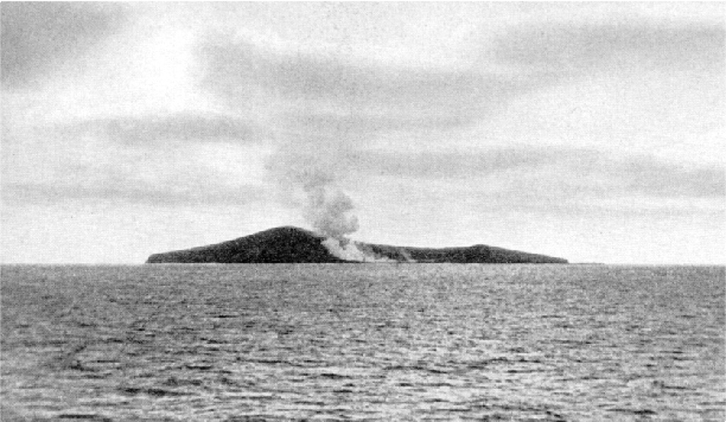
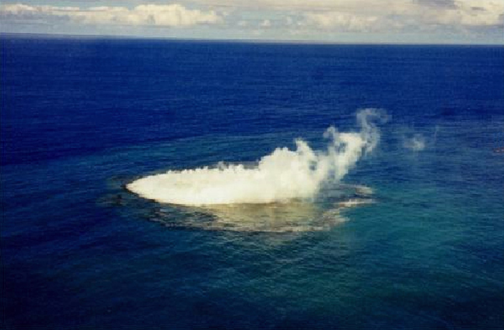
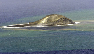
 A plume and discolored water from a submarine eruption were observed in January 1999. This unnamed submarine volcano, 35 km NW of the Niu Aunofo lighthouse on Tongatapu Island, was constructed at the southern end of a submarine ridge segment of the Tofua volcanic arc extending NNE to Falcon Island. The first documented eruptions took place in 1911 and 1923. An ephemeral island was formed during this eruption in 1999; prior to this the summit was 13 m beneath the sea surface.
Photo by B. Hutchins, 1999 (published in Taylor, 1999).
 An eruption plumes rises from the Prometheus vent at West Mata submarine volcano summit in May 2009. A November 2008 NOAA Vents Program expedition to the Lau Basin had discovered hydrothermal plumes from an actively erupting site on the summit of West Mata volcano. During a return trip in May 2009 explosive and effusive activity was observed from Hades, a vent on the SW flank, and explosive activity ejecting ash and bombs was seen from a scoria cone at the Prometheus vent.
Courtesy of NSF and NOAA Ocean Exploration Program, 2009.
 An aerial photo of Late taken in July 1990 shows the main summit crater breached to the SE and a NE graben occupied by large pit craters, the largest of which contains a saltwater lake. Except for remnants of a small lava plug in the summit crater, no fresh lava flows are present. The small, 6-km-wide island rises 1,500 m from the sea floor, with its conical summit reaching more than 500 m above sea level.
Aerial photo by Tonga Ministry of Lands, Survey, and Natural Resources, 1990 (published in Taylor and Ewart, 1997).
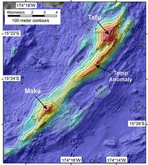 A bathymetric map prepared during a NOAA Vents Program expedition in November 2008 shows two submarine volcanoes, Tafu (Tongan for "source of fire") and Maka (Tongan for "rock"). The volcanoes lie along a NE-SW-trending ridge on the southern part of the back-arc NE Lau Spreading Center (NELSC). The November 2008 expedition discovered submarine hydrothermal plumes consistent with recent (maybe days to weeks) submarine lava effusion from Maka volcano.
Courtesy of NOAA Vents Program, 2008.
 Seen from the NE, Fonualei volcano is a small, less than 2-km-wide island that contains active fumaroles in the crater, which is breached to the SW with a fresh lava flow extending to the sea and forming a rugged shoreline. Blocky lava flows from a central cone have reached the sea through notches in the caldera rim. Eruptions have been recorded since 1791.
Photo by Paul Taylor (published in Taylor and Ewart, 1997).
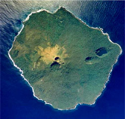
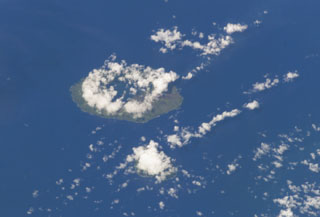 Clouds almost entirely obscure the small island of Kao (lower-center) in this NASA International Space Station image, and a circular cloud pattern rises above the caldera rim of the larger island of Tofua (left-center). No historical eruptions are known from Kao, and fresh-appearing lava flows are not seen, although the absence of sufficient time for erosion to produce deep gullies or high sea cliffs suggests a very recent origin.
NASA International Space Station image ISS008-E-14026, 2004 (http://eol.jsc.nasa.gov/).
This is a compilation of Tonga volcano information sources, such as official monitoring or other government agencies.
| Volcano Observatories | |
|---|---|
| Tonga Geological Services, Government of Tonga | |
| Tonga Meteorological Services, Government of Tonga | |
| Additional Information Sources | |
|---|---|
| Government of Tonga | |
| Consulate of the Kingdom of Tonga | |
| Volcanic Ash Advisory Center | |
|---|---|
| Wellington Volcanic Ash Advisory Center (VAAC) | |
| - Wellington VAAC Notices | |